 Aerodrome Traffic Zone (ATZ)
An Aerodrome Traffic Zone (ATZ) is a cylindrical volume of airspace around licensed civilian aerodromes and around some military aerodromes. They are established to give protection to aircraft at the critical stages of flight when departing, arriving and flying in the vicinity of an aerodrome. They assume the classification of the airspace in which they are located.
The lateral dimensions of the ATZ are dictated by the length of the longest runway.
Where the longest runway is greater than 1850 metres in length the zone will normally extend from the surface to 2000 feet above ground level (agl) with a radius of 2.5NM around the midpoint of the longest runway.
Where the longest runway is 1850 metres or shorter in length the zone will normally extend from the surface to 2000 feet agl with a radius of 2.0NM around the midpoint of the longest runway for aerodromes. (Also see the Air Navigation Order 2016 article 5(3)(a)).
Around an offshore installation, the zone will normally extend from the sea level up to 2000 feet above mean sea level with a radius of 1.5 NM. An ATZ is subject to Rule 11 of The Rules of the Air Regulations 2015 during the notified hours which can be found in the UK AIP en-route section at ENR2 or, in the case of civil licenced aerodromes, in the AIP Aerodrome Section. Rule 11(1) states:
| Type of Aerodrome | Rule 11 applies: |
|---|---|
| A Government aerodrome. | At such times as are notified. |
| An aerodrome having an air traffic control unit or flight information service centre. | During the notified hours of watch of the air traffic control unit or the flight information service centre. |
| A national licensed aerodrome or an EASA certificated aerodrome having an air/ground communications service unit with aircraft | During the notified hours of watch of the air/ground communications service unit |
Good airmanship would be to assume that an ATZ is ACTIVE if there is any doubt regarding its status. At many aerodromes, outside the notified hours, based General Aviation, National Police Air Service (NPAS) and Helicopter Emergency Medical Service (HEMS) aircraft may operate under local procedures.
Whilst a permanent ATZ is always in situ, the entry requirements in accordance with Rule 11 are only applicable during the notified hours of watch (as per the UK AIP or in the relevant NOTAM). Details of such hours can be found in the aerodrome directory (AD) section of the UK AIP for licenced civil aerodromes (in AD 2.18 AIR TRAFFIC SERVICES COMMUNICATION FACILITIES) or, for military aerodromes, in the En-route section (ENR) 2.2 (OTHER REGULATED AIRSPACE).
If the aerodrome is served by an Air Traffic Control unit pilots must obtain permission before entering the ATZ. If it is served by a Flight Information Service Officer or Air-Ground Communication Service, the pilot must obtain information to enable the flight to be conducted safely within the ATZ.
In addition, the commander of an aircraft flying within the ATZ of an aerodrome must
- cause a continuous watch to be maintained on the appropriate radio frequency notified for communications at the aerodrome; or
- if this is not possible, cause a watch to be kept for such instructions as may be issued by visual means; and
- if the aircraft is fitted with means of communication by radio with the ground, communicate the aircraft’s position and height to the air traffic control unit, the flight information centre or the air/ground communications service unit at the aerodrome (as the case may be) on entering the aerodrome traffic zone and immediately prior to leaving it.
Learn more > Aerodrome Traffic Zone
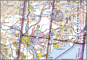
An ATZ is marked as a circle of dots with the aerodrome name and elevation (in feet amsl) as per the example below: A civilian aerodrome will be labelled using blue type and a military aerodrome will be labelled using magenta type.
| Aerodrome | ICAO/Initial Contact Frequency | Aerodrome elevation (feet amsl) |
|---|---|---|
| Cosford | EGWC/135.875MHz | 272 |
| Wolverhampton / Halfpenny Green | EGBO/123.005MHz | 283 |
Be aware that “neighbouring” ATZs can have differing vertical limits. In the above example Cosford ATZ vertical limit is 2,272 feet amsl whereas Wolverhampton Halfpenny Green is 2,283 feet amsl. In the example below, Exeter’s ATZ extends to 2,102 feet amsl but Dunkeswell’s extends to 2,839 feet amsl. Even if you overfly Exeter’s ATZ by 500 feet you would still infringe Dunkeswell’s unless you adjust your altitude along the route or call Dunkeswell and obtain information to enable the flight to be conducted safely within the ATZ.