 Altimetry
A significant number of airspace infringements are caused by pilots using an incorrect altimeter setting. The pilot may believe that they are remaining outside notified airspace by being either below or above, but, they are actually flying higher or lower than they think.
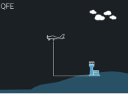
QFE (the atmospheric pressure at aerodrome elevation)
When QFE is set, your altimeter will indicate your height above the elevation of the aerodrome. This is useful in the visual circuit environment and in the ATZ. QFE should ordinarily only be used when flying in the vicinity of an airfields ATZ and/or traffic pattern.
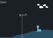
QNH (the atmospheric pressure at mean sea level)
When QNH is set your altimeter will indicate your altitude above mean sea level. When the Airfield QNH is set, the altimeter will indicate the elevation of the airfield correctly at the airfield reference point.
QNH is essential for avoiding airspace which has limits defined as an altitude, avoiding Glider Launch Sites where a maximum altitude of winch launch is charted and any Prohibited, Restricted or Danger Areas that have an upper limit defined as an altitude. When flying, remember to check (and update if necessary) the QNH value that you have set. This can easily be done by calling an Air Traffic Service Unit or listening to ATIS or VOLMET broadcasts.
A clue to the rate of change of QNH over a given area can be the strength of wind. Stronger winds result from greater changes in pressure and hence tend to indicate a more rapidly changing QNH.
Regional Pressure Setting (RPS)
RPS is a forecast (not an actual) value of the lowest atmospheric pressure at mean sea level (MSL) within an Altimeter Setting Region (ASR) which area given names such as ‘Portland’ or ‘Cotswold’. These values are available hourly for the period H+1 to H+2 and may be obtained from all aerodromes having an Air Traffic Service, from UKFIS, London Area Control (Swanwick) and Scottish Area Control (Prestwick), or by telephone; there are 20 ASP in the UK and are listed in the UK AIP at ENR1.7. The boundaries of each ASR are marked on the VFR charts with pale blue 2-barred crosses.
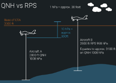
- When an RPS is set your altimeter will indicate your altitude above the forecast setting.
- Aircraft using this setting will never be lower than the indicated altitude.
RPS were introduced to aid terrain clearance in large areas where there was no local QNH reporting station, or where communications were poor. Caution should be exercised when given and operating with and RPS set, as this will not be a valid pressure setting for avoiding airspace which has a base defined as an altitude.
There are sectors of Airspace that, when operational, do not form part of the RPS system such as within all CTRs, within and below all TMAs, CTAs except Airways and the Worthing and Clacton Control Areas. When flying in Airspace below TMAs and CTAs detailed above, pilots should use the QNH of an adjacent aerodrome if flying at or below the Transition Altitude. It may be assumed that for aerodromes located beneath such Areas, the differences in the QNH values are insignificant. When flying beneath Airways whose base levels are expressed as Altitudes pilots are recommended to use the QNH of an adjacent aerodrome in order to avoid penetrating the base of Controlled Airspace.
REMEMBER, using RPS can cause you to be HIGHER meaning:
- Increased protection from obstacles below BUT
- Greater risk of penetrating the base of airspace above.
Standard Pressure Setting (SPS) 1013.2 hPa
The SPS setting should be used when flying near to airspace with any level defined as a Flight Level; at or below the Transition Altitude the QNH should be used for vertical reference.
When SPS is set your altimeter will indicate Flight Levels (FL). The SPS should only be used when flying above the Transition Altitude. In the UK the Transition Altitude is generally 3,000 feet with exceptions in, or beneath, the Airspace specified at UK AIP ENR 1.7 paragraph 4.1 where it is 5,000 feet or 6,000 feet. Transition Altitudes are shown in the aerodrome directory in AD 2.17. Due to these variations, it is essential that you check your chart and/or the AIP before you fly. Care should be taken as airspace (airways, CTA etc) can be shown on charts as a Flight Level or as AMSL, in addition some charts (the 1:250k) do not show airspace above 5,000 feet altitude.