 Radio Telephony
Radio Telephony (RT) is a very important element of effective pre-flight route planning and, if done correctly, will allow for a safe and expeditious flight and not pose as a distraction in flight. As mentioned earlier in the Route Planning section of this tutorial, a respected flight instructor once said, “Do not fly a route that you have not first flown on your dining room table” and this applies to the use of RT also. Planning exactly where you are going to contact the next Air Traffic Service Unit (ATSU) along your route will allow you to plan your transmissions and always make use of the most appropriate Air Traffic Service (ATS). This guidance has been written by a current Flight Instructor and Flight Radio Telephony Operators Licence (FRTOL) Examiner.
Why is Radio Telephony important?
In short, RT is an aid to safety. It can act as another pair of eyes by allowing all airspace users to build a 3D picture of what it is happening in the airspace around them; not just at one moment in time but also how the airspace is likely to look in the near future. This can be achieved by using the standard initial call in the air when making initial contact with an ATSU. The initial call should be in the following format.
- Ground station callsign
- Aircraft callsign
- Request
Only when two-way communications has been established with the ground station should you pass the following information. The ground station may say “pass your message”.
- Aircraft callsign
- Aircraft type
- Departure point
- Destination
- Position
- Level
- Additional information
Your additional information should contain your routing details that relate to the portion of the flight while you are communicating with this specific ground station. For example, on a flight from Goodwood to Caernarfon, Farnborough Radar are unlikely to need to know your planned routing over North Wales but it would be useful for them to know your planned routing while you are operating within their LARS area so they are able to pass relevant traffic and airspace activity information to you. An example of such an initial call is:
- “Farnborough Radar, G-ABCD, request Traffic Service.”
- “G-ABCD, Farnborough Radar, pass your message.”
- “G-ABCD, Cessna 172, Goodwood to Caernarfon, 3 miles east of VRP Butser Hill Mast, altitude 3,700 feet, routing via Compton, VFR.”
This routing information may prompt the controller at Farnborough to remind the pilot that Lasham Glider Site is active. The pilot should know this information already as they should have identified Lasham as a Threat during their pre-flight planning but the information from Farnborough serves as a reminder to be cautious as to their proximity to the site.
Furthermore, obtaining a service from the most relevant ATSU for your area of operation will ensure you have the correct QNH set for the airspace you are operating in and proximate to. The Airspace Infringement Team at the CAA has noted that several infringements of CTAs and TMAs occur because pilots are operating on an inappropriate or incorrect pressure setting, such as the Regional Pressure Setting (RPS), when operating proximate to controlled airspace. As pilot in command, you do not have to accept an RPS if you deem it inappropriate for your operation. Do not be afraid to request the QNH.
Radio planning while route planning
An earlier section explained the importance of thorough pre-flight planning incorporating regulated sources of information, such as the UK AIP and VFR charts, and application of effective Threat and Error Management (TEM). The same is true for RT and it is important to incorporate radio planning into your route planning. For example, deciding which is the most appropriate ATSU on each sector of your route as well as deciding the most appropriate service to request based on the limitations of the licence and equipment of the ATSU you are talking to, and the day and time that your flight is going to take place.
Once you have completed your pre-flight route planning as shown in the section of this tutorial, it is time to start considering who you will request a service from, the type of service that you will ask for and where you will make your radio calls.
It is good practice to apply the following order of priority during your flight planning when it comes to deciding who to request a service from:
- If within 10NM of an aerodrome with a suitable ATS (FIS/ATC), or underneath their airspace, or within 15NM or 5 minutes flight time, whichever is the sooner for a MATZ obtain a service, from that Unit. If not,
- If there is a Lower Airspace Radar Service (LARS) available, obtain a service. If not,
- Utilise an appropriate Frequency Monitoring Code (FMC) where available. If not,
- Obtain a service from London or Scottish Information.
The above guidance does require some flexibility especially with airfields which are proximate to other airfields or controlled airspace.
The Designated Operational Coverage (DOC) of all ATSUs can be found in the UK AIP under the relevant aerodrome in section AD 2. LARS coverage including service radius, service area, and operational hours can be found in the UK AIP ENR 1.6 ATS SURVEILLANCE SERVICES AND PROCEDURES and a chart showing LARS coverage areas is also available at ENR 6-11.
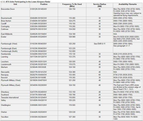
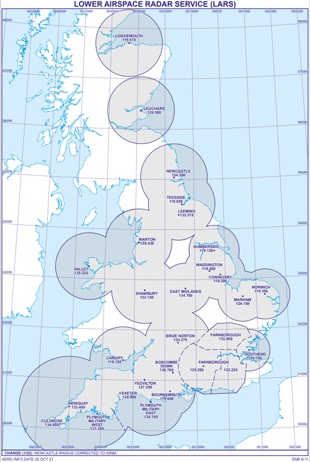
This guidance does require some flexibility especially with airfields which are proximate to other airfields or controlled airspace. The Designated Operational Coverage (DOC) of all ATSUs can be found in the UK AIP under the relevant aerodrome in section AD 2. LARS coverage including service radius, service area, and operational hours can be found in the UK AIP ENR 1.6 ATS SURVEILLANCE SERVICES AND PROCEDURES and a chart showing LARS coverage areas is also available at ENR 6-11 (see below).
Information on the notified areas of London Information and Scottish Information including their vertical limits, times of availability and frequencies can be found in UK AIP ENR 6-32 LONDON ACC – FIS SECTORS and ENR 6-33 SCOTTISH ACC FIS SECTORS.
Local flight example
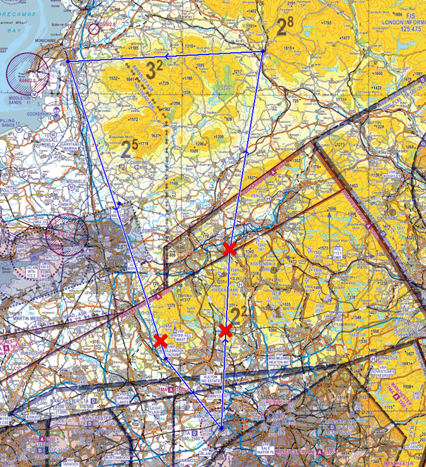
The following example of a local flight from Manchester Barton to Manchester Barton via Accrington, Settle, Lancaster, and Middlebrook Stadium Visual Reference Point (VRP) will detail the process of applying the above guidance and how best to mark this on your chart.
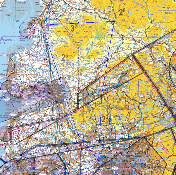
Once you have chosen your routing you can start to annotate your frequency changes on the chart. Using the above guidance, a Basic Service will be obtained from Barton Information until 10NM away from the aerodrome. At this point you should be planning to change from the Barton frequency and deciding which frequency you will be changing to next. In this case, you will still be operating underneath the Manchester TMA; therefore, monitoring Manchester Radar on 118.580 MHz and selecting the Frequency Monitoring Code (FMC) 7366 would be suitable. Information on the areas in which FMCs can be used can be found in UK AIP ENR 6-80 FREQUENCY MONITORING CODE (FMC) AREAS and on the FMC card.
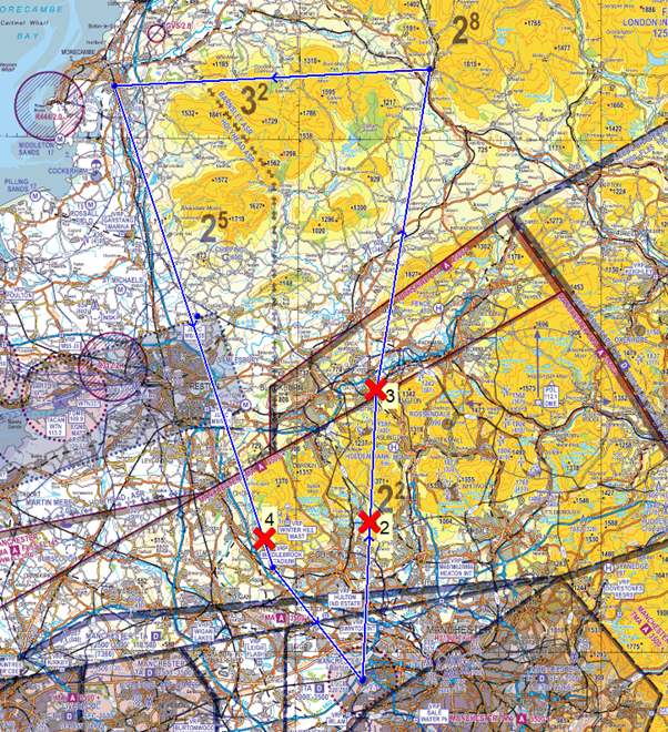
Further along the route, you are no longer going to be operating underneath the Manchester TMA and will be continuing to head away from the controlled airspace; therefore, it would be prudent to change to a new frequency. Looking at the priority list, you will not be within 10NM of an aerodrome therefore you would move to point 2 on the list. By checking the UK AIP, you note that Warton provide a LARS up to 40NM between specified times during the week. Your flight is due to take place during those times and there is not a NOTAM in force which notifies Warton LARS as not available. Based on this information, Warton Radar would be best placed to provide you with a service and a symbol should be placed on your chart, in this case at Accrington. Running your finger along your route, you note that the rest of your flight will take place within 40NM of Warton, and you can see that you will not pass within 10NM of an aerodrome that is able to provide you with a service (other than Warton) for most of your flight until you reach Barton again. Taking your navigation ruler, measure 10NM from the Barton ATZ and annotate your chart with a frequency change symbol.
After a double check, you are satisfied with your plan therefore you should now start to number your frequency changes. Frequency number 1 will always be the one for your departure aerodrome, in this case Barton, and the numbers should run in chronological order along your route. If you have decided that you are going to talk to the same ATSU twice then you should use a separate number for both occasions to keep the chronology correct.
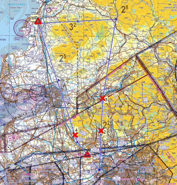
You should also mark any major points along your route such as geographical limit points before the edge of airspace. In the case of this flight, you could place a marker 15NM from the edge of the Warton MATZ to remind you to request a MATZ penetration (MP) service in good time. A limit point should also be placed prior to the edge of the Barton ATZ to remind you to not proceed beyond that point without having satisfied the requirements of Rule 11 (4) of The Rules of the Air Regulations 2015.
Your PLOG should reflect the plan you have created on the chart and should include the ground station callsigns, frequencies, any FMCs, and the service you are going to request such as in the example table below. You can also anticipate the squawk codes you may be allocated by checking the squawk code allocation at UK AIP ENR 1.6 during the planning stages. At the time of writing this tutorial, Barton is allocated 7365 and Warton is allocated 3641 – 3657 therefore you can anticipate, and note down, the first two digits of the squawk code you expect from Warton Radar on your PLOG. It is important to remember that you cannot select one of these squawk codes unless directed to do so by the ATSU, unless of course, it is an FMC.
| Number | Callsign | Frequency | Squawk | Request |
| 1 | Barton Information | 120.255 | 7365 | Taxi |
| 2 | Manchester Radar | 118.580 | 7366 | FMC |
| 3 | Warton Radar | 129.530 | 36__ | Traffic Service |
| 4 | Barton Information | 120.255 | 7365 | Basic Service and Join |
Prior to conducting the flight, you should ‘fly’ the route at your planning table and practise your initial calls and responses. This will ensure that you are as prepared as possible for the RT aspects of your flight and will reduce the amount of thinking you have to do in the air in relation to your radio. For example, at Number 2, your initial call in the air should be:
- “Warton Radar, GABCD, request Traffic Service.”
- Once two-way communications have been established you may pass your reply. Warton Radar may say, “pass your message”.
- “GABCD, PA28, Barton to Barton, Accrington, altitude 3,200 feet, routing via Settle, Lancaster, and VRP Middlebrook Stadium, VFR.”