 Prohibited and Restricted Areas
Prohibited Areas are areas in which flight is not permitted. Restricted Areas are areas in which flight is only permitted under certain circumstances.
These areas are established by secondary legislation under article 239 of the Air Navigation Order 2016 (ANO) and usually apply to all aircraft as defined in the ANO.
The areas are established around some prisons, nuclear sites and locations where specific security restrictions are required, such as around royal residences and Central London and at areas of Critical National Infrastructure.
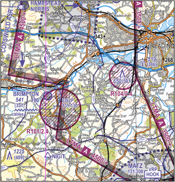
A Prohibited Area has a 3 letter (EG P) and 3 number code relating to its location in degrees of latitude (eg EG P611 which is located at 56oN); a Restricted Area is given a 3 letter (EG R) and 3 number code relating to its location in degrees of latitude (eg EG R212 which is located at 52oN). On official VFR Charts the areas are all indicated by bold purple cross-hatched boundary lines with their identification number (eg R101) and associated maximum altitude extending from the surface (2.4 signifying 2,400 feet above mean sea level); where the area does not restrict all aircraft types, a note will be added to the chart legend.
A list of specific areas can be found in the UK AIP in the En-route (ENR) section 5.1; this list includes vertical limits, details of the restrictions and the number of the associated Statutory Instrument.
A temporary restriction of flying can be made under article 239 of the ANO, known as a Restricted Area (Temporary) or RA(T), under the following circumstances:
- for the intended gathering or movement of a large number of persons;
- for the intended holding of an aircraft race or contest or of a flying display; or
- for national defence or any other reason affecting the public interest.
As these areas are established for specific, short-term events and activities, they will not be charted but will be notified by NOTAM and, where time permits, through the issue of a Mauve Aeronautical Information Circular (AIC). The AIC will be issued on the AIS website. In addition, the information will feature in the daily AIS Information Line message (08085-354802) and 01489-887515. The NOTAM and AIC will, together, not only detail the location and vertical extent of the restriction but will also provide details of the activity taking place/reason for the restrictions as well as access conditions and arrangements for the airspace.