 Route Planning
A respected flight instructor once said “Do not fly a route that you have not first flown on your dining room table”.
Once you have decided where you intend you fly it is essential that you plan it thoroughly, and, on the day carry out a comprehensive meteorology brief reviewing the weather for your route and destination. Although the sky may be clear at your home (departure) aerodrome, your destination may be 100 miles away and may have localised weather, for example, if close to the coast the weather could be very different. In addition, the UK has a very changeable climate and you may encounter other localised weather en route. Controlled flight into terrain and loss of control in IMC continue to be factors of many GA accidents. Attempting or continuing VFR flight in poor weather is often a cause of this.
Carrying out a NOTAM brief is another of the first items in pre-flight planning. This is because airspace/aerial activity, along with weather, are two of the main factors that set the parameters of your flying. It is no good spending hours planning a route only to discover that the destination aerodrome is in fact closed for an event that day or that the weather is obviously not going to be suitable. It may well be necessary to revisit this brief shortly before departure to check for updates (Discussed later)
An earlier section explained the importance of making an accurate self-assessment prior to flying by asking yourself “Can I really say, I’m Safe?”. The mnemonic IMSAFE provides a logical checklist to help make that decision. Once that aspect of planning is complete it is time to turn your attention to the physical route to fly.
When planning the route, it is essential that you incorporate effective Threat and Error Management (TEM). In the UK, it is very likely that your route will take you close to some quite complex airspace structures which you may intend to, or need to, remain clear of. Remember this will be in addition to any unusual aerial activities of a temporary nature that you learn of when carrying out your NOTAM brief. When able, Take 2 by planning to remain 2NM laterally or 200 feet vertically clear of the edge/base of controlled airspace in order to reduce the consequences of turbulence, distraction or external influences. Hopefully, you will be using a VFR Moving Map but consider also carrying a backup device or paper chart marked, and folded, with the route visible. This will act as a reserve in case the device on which you are using the Moving Map fails and is a good application of TEM. Make sure your chart is up to date but remember that even the latest chart may not include all changes to airspace along your route. A comprehensive guide to VFR chart resources can be found on the NATS Aeronautical Information Service website and is available free to all users.
Having drawn a line, whether electronically or on the paper chart, you should check for any airspace above or below your route. In ‘Taking 2’, plan for maximum ‘airspace clear altitude’ (the lower limit of vertical controlled airspace less 200 feet if possible) for each leg alongside minimum airspace clear altitude; perhaps annotate this alongside the MSA calculation:

Route Planning to Avoid an Infringement
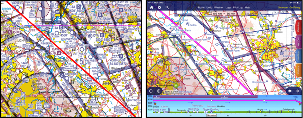
This section will look at a practical example of planning including how to avoid infringing. You plan to fly from Manchester Barton (EGCB) to Northampton Sywell (EGBK) (Figure 1). First get your chart(s) out, Is it the correct chart? (Manchester Barton is on the edge of the “southern” chart, how much “space” around it do you need to see, feed this on to your TEM?) Make sure it is up to date, or (or in the case of an electronic chart check that the latest updates have been applied to your VFR Moving Map application. Then look at the route and see where an infringement may happen and plan to prevent it.
Note: Although the Manchester Low level Route (LLR) was replaced by Restricted Area EGR323 (North West Transit Corridor) the principles of the planning approach still apply. This example will be updated once new charts are available. A list of narratives relating to known infringement hot-spots, and methods to mitigate the specific local risks, can be found at https://airspacesafety.com/hot-spot-narratives/
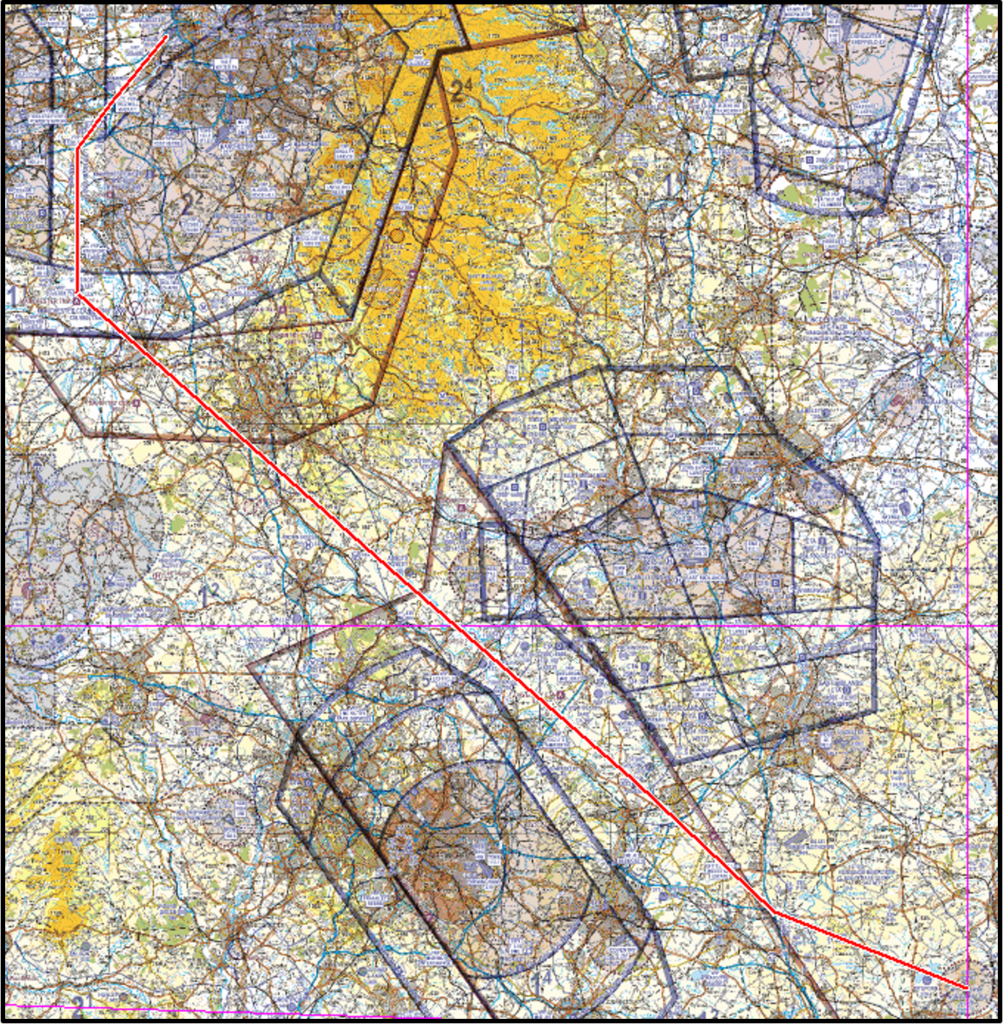
There are several such risk areas along the route. Restricted Area EGR323 is the first (Figure 2). What are the issues, considerations (threats?) here?

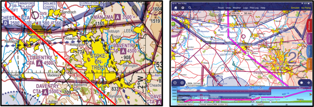
The maximum altitude here is a big consideration leading to the most obvious error of flying too high when flying through Restricted Area EGR323. The less obvious error, and from the actual infringement reports the most likely to happen, is not descending from a higher cruise level early enough and flying into controlled airspace above the ‘entrance’ of Restricted Area EGR323. similarly, another error, although not as common, is starting to climb too early when exiting Restricted Area EGR323 and inadvertently climbing up through the base of controlled airspace on the way out. Ideally the plan should include a fixed waypoint before the entry by which the level that you intend to fly at through Restricted Area EGR323 must be established (in this case the VRP at Thelwall Viaduct would be reasonable) and a point at the other end where you know that you are clear and safe to climb (in this case Ashcroft). What pressure setting is this altitude based on? Remember, you must have the altimeter set correctly before you reach the entry waypoint. Also remember to check if there are any specific rule-sets applicable to the airspace in which you intend to fly in. Use the UK AIP Aerodrome Directory section (AD 2.22 Flight procedures) to check for any specific conditions.
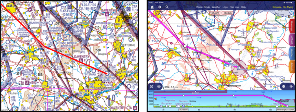
Having left Restricted Area EGR323 you will probably want to climb from the low level that you have been flying at for the 12NN length of the route. The threat here is that the Manchester CTA immediately south of Restricted Area EGR323 has a base of just 2,500 feet and it won’t take long for most aircraft to reach that level. Make sure that you have a plan that will keep you below the CTA with a margin for error. So, in this case using the “Take 2” methodology, set an initial climb limit of 2,300 feet. Having flown past Crewe, the lowest limit of controlled airspace for the rest of the way to Sywell is 4,500 feet (the Daventry CTA which overlays Stoke-on-Trent – Figure 3) so, given usual cruising levels, vertical infringement shouldn’t be an issue. However, do make sure that you have noted an upper limit for your flight, say 4,300 feet on your PLOG just in case you get tempted to fly higher at some point. It is not uncommon for pilots to miss some of the annotations on the chart in-flight, particularly if it is turbulent or if there are other things to do such as FREDA checks that draw your attention away from navigation. To make these details stand out more to you in flight, you may consider highlighting them; again, a good application of TEM.
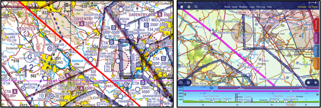
As they are notified airspace, it is possible to infringe Aerodrome Traffic Zones (ATZ). [MC1] You will note that along your route, you pass close to the Tatenhill ATZ (Figure 4). This is a threat which needs to be managed. With an upper limit of 2,450 feet above mean sea level, you could fly over it. Equally you could plan around it. Give some consideration to both, we’ve identified the threat but planning to both be above it and laterally clear of it builds in mitigations that could trap either navigation or altimetry errors. Exercise caution here though, will additional altitude lead to another potential issue? Where is East Midlands CTA? Remember to be careful when flying close to an ATZ; the highest rates of potential mid-air collision are in the vicinity of aerodromes, so it is important to maintain a very good lookout. Even if, as in this case, you plan to remain outside the ATZ, it is good airmanship to call on the frequency to alert aerodrome users of your intentions to pass close by; once you have done that, continue to monitor the frequency so that you develop increased situational awareness on local traffic to supplement your enhanced lookout.
Whatever route you choose to take, you must stay out of the ATZ unless following the requirements for ATZ entry which are published in Rule 11 of The Rules of the Air Regulations 2015.
Although you might find the route easy to follow and fly a straight line all the way to Sywell it is worth considering what may distract you or cause you to deviate from the route (such as avoiding other aircraft, localised weather or something on the ground that you, or your passenger, wants to see). If you see some weather ahead or become less certain of your position are there any ‘open’ areas that you could orbit? Is there an ATC unit that could help you in this situation or is there a Frequency Monitoring Code (FMC) that could be selected on your transponder? It is a good practice to use an FMC when operating close to controlled airspace. As you approach the East Midlands CTA (Figure 5) which is to the east of your intended track, if you do not want an air traffic service, listen out on 134.180MHz and then set the FMC of 4572 on the transponder with Mode C; ensure that the radio volume is still at a suitable level to that you hear any transmissions for you. If for any reason you do get unsure of your position or even lost, you can get instant help from East Midlands ATC; even if you don’t realise that you may be about to infringe they can call you and offer help.
As you approach Sywell your route will take you close to Husbands Bosworth gliding site, is there a threat here?
The threat here is not an infringement as such, but you will note from the legend that gliders are winch launched to 3,600 feet above mean sea level (marked by a G with 3.6 in the circle). Although gliders will be operating in the vicinity higher than 3,600 feet, a cable strike could be fatal for you and any glider attached to the cable. A slight ‘dogleg’, as shown in Figure 6, will mitigate the risk of a cable strike and encounters with gliders at critical stages of flight and will not add a great distance onto the route.
As part of your plan before you depart, you should consider how you will approach the aerodrome at Sywell. This can be done by referring to the UK AIP for licenced aerodromes (in the Aerodrome Directory (AD section)), by using one of a number of Pilot VFR Guides, by visiting the aerodrome website on the internet, by asking for a verbal brief when you telephone the aerodrome to book-in/obtain PPR or, why not use a combination of these?
As part of your planning, don’t forget that temporary airspace may be active along the route that will not be shown on the chart. The temporary airspace may be a Restricted, Prohibited or Danger area. During a normal summer period there are many Temporary Restricted Areas (RA(T)) put in place to protect air displays or festivals, often at locations that may not seem to be an obvious candidate. With the significant increase in the use of Remotely Piloted Aircraft Systems (drones) there are frequently Temporary Danger Areas (TDA) established to segregate their operations. The UK NOTAM system will advise you of these areas. Mark them on your paper chart and have a plan to avoid them. Just before you start the engine, make a quick telephone call to the NATS AIS Information Line on 08085-354802 or +44(0)1489-887515 for information on any last-minute establishment of restricted airspace.
Remember to always have a Plan B. If you are planning a controlled airspace (CAS) crossing, ensure that you have an alternative routing, and sufficient fuel to avoid the airspace in the case of a clearance not being possible. When devising your Plan B, be equally thorough with your planning to ensure that all the Threats are identified and managed and that you can implement it simple and effectively in-flight.
When planning you may wish to make full use of the following resources:
- Check NATS AIS for NOTAM using the NATS AIS website
- Check http://skywise.caa.co.uk/for the latest alerts and advice from the CAA
- Check https://airspacesafety.com/ for infringement updates and guidance