 Meteorology
The current (observed) and forecast meteorological (Met) conditions will play a major part in a pilot’s planning and allow them to decide if a flight will take place, where a flight will operate and the route to be taken. A pilot’s ratings will also form part of that decision-making process. Misinterpretation of weather data and associated decision making has been identified as a key factor behind some infringements. The principles of Threat and Error Management are to encourage pilots to have situational awareness of the risks that might put them in danger and to consider plans to mitigate those risks. Identifying weather related risks is an important factor, so an understanding of how to manage risks such as unexpected weather changes is a fundamental part of good airmanship. Possible areas of specific risk areas are:
- Low Visibility (including Fog).
- Cloud (Low cloud base, Convective clouds etc).
- Showers and Thunderstorms.
- Wind and turbulence.
- Making the decision – pre-flight risk assessment (en-route, at destination and alternatives).
Meteorological forecasting and climatological services for civil aviation in the United Kingdom are provided by the Met Office designated as the Meteorological Air Navigation Service Provider (ANSP) for the UK. The Met Office provides a host of valuable Met information that forms part of an effective planning process. Details of Met Services, Area of Responsibility and an outline of observations and reports are found in the UK AIP in GEN3.5. All regulated products are available free of charge via the Met Office Aviation Briefing Service. The Aviation Briefing Service also includes additional UK and European information such as synoptic charts, weather map viewer, observed and forecast map layers (satellite imagery, lightning and thunderstorm layers), rainfall radar and Aerodrome Warning email alert service. Having briefed against regulated products pilots can, if necessary, contact Met Office meteorologists for further forecast clarification.
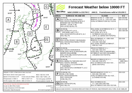
Metform 215 (Figure 1) provides a forecast of in-flight weather conditions below 10,000 feet for a 9-hour period centred on a fixed time. It is designed for use as either an area or route forecast.
The chart area shows the forecast position, direction and speed of surface fronts and pressure centres at the fixed time shown in the charts title box.
Zones of distinct weather are enclosed by continuously scalloped lines, each zone being identified by a letter within a box. Subzones may also be included and are indicated by a letter followed by a number: i.e. D1 in the example below.
For each zone (identified by its Letter/number on the left-hand chart) the text will detail the expected surface horizontal visibility, including any sub zones referred to within the text and special or temporal variations within the zone. A general outlook is also included and includes the principle weather changes expected during the 7-hour period following the end of the chart validity.
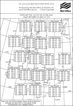
Metform 214 (Figure 2) provides forecast upper winds and temperatures across the UK and Ireland separated by 2.5O of latitude and were possible the same number of degrees of longitude.
TAFs (Terminal Aerodrome Forecasts) are forecasts available in coded and plain language. Larger aerodromes often produce 9, 24 or 30-hour TAFs which will give a good indication as to when particular weather will be experienced. TAFs valid for 9 hours are updated and re-issued every 3 hours and those valid for more than 12 hours, every 6 hours. Amendments are issued when significant changes occur (particularly if the deterioration or improvement has not been forecast or is mis-timed. Patterns can be established by looking at several TAFs over a given area. Where uncertainty exists as to the forecast, the terms PROB30 and PROB40 are used meaning a 30% and 40% probability respectively of the referenced conditions occurring. Where the term TEMPO is used, the conditions following these groups are expected to last less than one hour in each instance and in aggregate less than half the period indicated.
Note: Values in TAFs do not represent a single forecast value but rather a range of potential values (A table describing the range of wind, cloud and visibilities that TAFs cover can be found on the Met Office website in the Pilot Resources section).
METARs (Meteorological Terminal Air Report) are reports issued by accredited aerodrome meteorological observers based on a time rather than a period. They are normally updated every 30 minutes at HH+20 and HH+50. Weather reports on ATIS (Automatic Terminal Information Service) will be updated more often if the weather is changing frequently. Some aerodromes offer a telephone number, to access their live ATIS.
Met Local Special Reports or Forecast Amendments will be issued whenever significant changes have occurred or are expected to occur to the published report or forecast. These are published in a code format which is like the METAR and TAF formats (specific details are published in the UK AIP, GEN 3.5, Meteorological Services and CAP 746, Requirements for meteorological observations at aerodromes, Chapter 5). The meteorological information in Metform 215 and TAFs and METARs will give an indication of surface visibility but actual in-flight visibility can only be judged while in the air. Wind vectors used for navigation planning in Metform 214 should also be used as an indication. Using this wind vector information without validating it can result in a take-off with a navigation plan that will simply not work to the pilot’s expectations. It is also important to know the relationship between the relevant units of measurement so you can establish the in-flight visibility; depictions on charts are in nautical miles but visibility is reported in metres/kilometres. One nautical mile is approximately 1.85 kilometres; as an example, a visibility of 3,000 metres is less than the radius of an Aerodrome Traffic Zone.
ATIS
Automatic Terminal Information Service can be a useful source of weather (and other important) information available in the air giving current METAR information for a specific airfield. Generally, this service is only provided at larger airfields and details can be found in the information published by airfields in their aerodrome entry in the UK AIP, Part 3 (Aerodromes).
Do not tune to and listen to an ATIS at the expense of maintaining the necessary contact with the ATSU that you are working with without their knowledge.
VOLMET
The purpose of a VOLMET broadcast is to provide weather information to aircraft in flight. VOLMET reports are broadcast principally over high frequency (HF) radio by a number of civil and military stations located around the world. In the United Kingdom, there are four stations which provide VOLMET broadcasts on Very High Frequency (VHF) radio. In all cases, the station will use automated voice transmission to broadcast METAR information for a published list of aerodromes H24 from half hourly reports. VHF stations normally broadcast their information in a continuous loop updating the information as changes occur. The frequencies and stations served, and other information, are found in Table 3.5.7.1 in the UK AIP Gen 3.
Air Traffic and Flight Information Services
Remember that, subject to their workload, the ATC unit you are speaking to or the UKFIS provider will be able to access weather information on your behalf if requested.
Be prepared
Your pre-flight plan will have been made using forecast data which will have provided you with the most probable weather conditions that you are likely to experience during the forecast period. However, owing to the variability of meteorological elements in space and time and to limitations of forecasting techniques you must always be prepared to make airborne corrections to your pre-flight plan. The UK experiences very changeable and often unseasonal weather conditions so it is vital to focus on flight safety in IMC – i.e. making decisions when assessing whether, or where, to fly when IMC exist or are forecast – for example, taking more time to consider potential contingency plans and diverts to support effective decision-making en-route. It is good practice to train/remain current on using basic flight instruments in case of inadvertent entry into adverse weather conditions – an event which could result in loss of control due to spatial disorientation.
Weather in the British Isles can be very unpredictable and as such pilots need to have a good appreciation of conditions and trends en-route, at the intended destination and at any diversion aerodromes as well. The threats posed by weather conditions on the aircraft such as airframe and engine icing also need to be considered. When planning your route in the vicinity of controlled airspace, consideration should be given to the wind direction and turbulence. Any distraction associated with navigation, in-flight checks or dealing with passengers could lead to a pilot drifting off track or climbing into an infringement event.